Physical Address
304 North Cardinal St.
Dorchester Center, MA 02124
Physical Address
304 North Cardinal St.
Dorchester Center, MA 02124

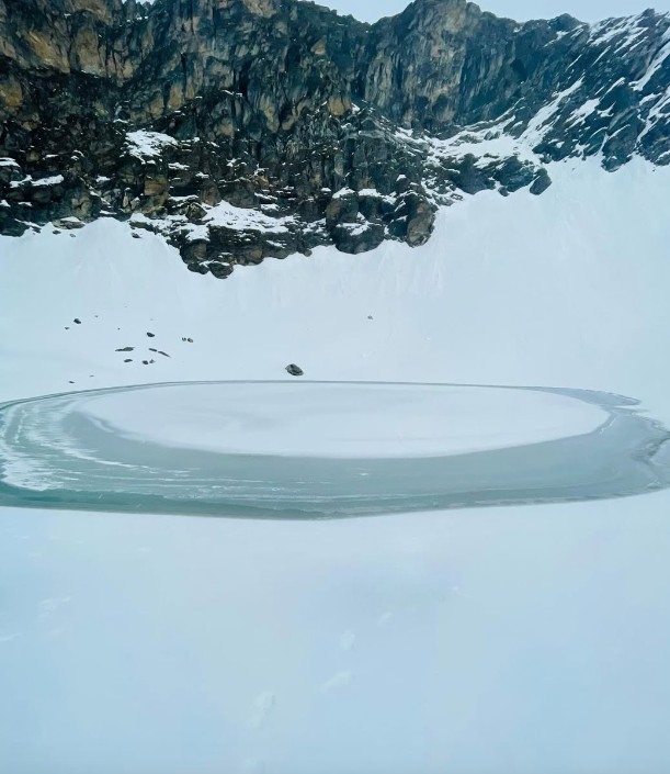
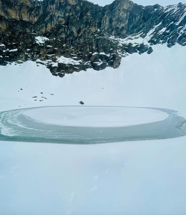
Roopkund is not just another Himalayan trek. It combines high-altitude meadows, long mountain walks, snow-covered terrain and one of the most unusual archaeological stories in the Himalayas.
The trail leads towards Roopkund Lake in Chamoli, Uttarakhand. The lake sits at about 5,029 metres above sea level and is widely known as Skeleton Lake because human remains have been found around it.
But there is something important to know before planning a Roopkund trek in 2026.
Access to the lake is currently subject to forest permissions and restrictions. Current trekking information says departures can operate only after the required permissions are granted. So don’t book your transport first and ask about permits later. That can turn a mountain trip into an expensive lesson.
This guide explains the route, difficulty, best season, itinerary, preparation, history and what you should know before considering a Roopkund trek package.
| Detail | Information |
|---|---|
| Location | Chamoli, Uttarakhand |
| Lake altitude | About 5,029 m |
| Popular name | Skeleton Lake |
| Main trekking region | Lohajung, Wan, Bedni Bugyal |
| Major highlights | Bedni Bugyal, Bhagwabasa, Roopkund |
| Trek grade | Difficult |
| Typical season | Late spring to early summer and autumn, subject to permissions |
| Experience needed | Good fitness and high-altitude trekking experience |
| Access | Subject to applicable forest permissions and current restrictions |
The exact itinerary can vary because weather, trail conditions and forest regulations can affect the route.
Roopkund lies in the Chamoli district of Uttarakhand, in the higher reaches of the Garhwal Himalayas.
The traditional trekking approach uses the Lohajung and Wan region before moving through high-altitude meadows and camps towards the lake. Uttarakhand Tourism’s Roopkund trek document lists a route through Rishikesh, Mundoli, Wan, Bedni Bugyal, Bhagwabasa and Roopkund. It describes the full traditional circuit as a long multi-day trek.
The route is not a simple walk from a roadhead to a lake.
You gain a lot of altitude, cross changing terrain and spend time in remote areas where weather can affect the trail quickly.
That is why preparation matters more here than simply counting kilometres.
The first answer is obvious: Roopkund Lake itself.
But the lake is only one part of the experience.
The trail passes through forests and large Himalayan meadows. Bedni Bugyal is one of the major highlights, with wide open grasslands and views towards peaks including Trishul and Nanda Ghunti. The traditional route then continues towards higher and colder terrain before reaching Roopkund.
The landscape changes as you climb.
Lower sections feel greener and more forested. Higher sections become more open, rocky and exposed. By the time you approach the upper camps, altitude becomes a much bigger factor than the scenery.
And yes, the scenery is excellent. But at 5,000 metres, even a beautiful view comes with a breathing tax.
Roopkund became famous because of the human remains found around the lake.
For years, different stories tried to explain who these people were and how they died. Some theories connected them with pilgrims, travellers or groups caught in extreme weather.
Modern scientific research has changed the picture.
A 2019 study published in Nature Communications examined genome-wide DNA from 38 individuals and combined it with radiocarbon dating and isotope analysis. Researchers found three genetically distinct groups among the sampled remains.
More importantly, the remains did not all come from one event.
The research found that one group dates broadly to around the 7th–10th centuries CE, while another group dates to roughly the 17th–20th centuries CE. This means the remains accumulated during separate periods rather than representing one single disaster.
That finding makes the story even more interesting.
The mystery did not simply disappear after scientific research. Instead, scientists discovered that the real history was more complicated than the popular stories suggested.
The traditional route passes through several important points.
A commonly described approach starts around Lohajung and continues towards Wan, Bedni Bugyal, Patar Nachauni, Bhagwabasa and finally Roopkund.
Different route versions exist, so you should not assume that every Roopkund itinerary follows exactly the same trail.
The Uttarakhand Tourism Board’s published Roopkund itinerary describes a longer route beginning from Rishikesh and moving through Mundoli and Wan before reaching Bedni Bugyal and Bhagwabasa. It gives approximately 103 km of total trekking distance for that particular extended itinerary.
Other modern itineraries use Lohajung as the main starting point and combine road travel with a shorter trekking approach.
The important point is simple: check the exact route before booking.
Distance figures on different websites often refer to different starting points and itinerary versions. Comparing them without checking the route can create unnecessary confusion.
Because access remains permission-dependent, treat the following as a traditional route framework rather than a guaranteed 2026 schedule.
Travel towards Lohajung, the main gateway for the Roopkund region.
Most of the day can involve road travel, depending on your starting point. Use this day to rest and prepare your backpack rather than trying to squeeze in extra sightseeing.
The route moves towards Wan and the surrounding forest section.
This part of the trek introduces you to the terrain gradually. Forest paths, village sections and changing slopes make the first trekking day feel very different from the road journey.
The trail climbs towards Bedni Bugyal.
This is one of the memorable sections of the route. The dense forest gradually gives way to open high-altitude meadow landscapes.
Bedni Bugyal sits at around 3,354 metres and is also associated with the Nanda Devi Raj Jat pilgrimage route.
The trail continues into higher terrain.
Depending on the approved itinerary, camps can be located around areas such as Patar Nachauni or Bhagwabasa.
This is where the trek starts feeling serious. The air gets thinner, the temperature drops and the trail gives you fewer chances to pretend you are still on a casual weekend walk.
The lake day is the main objective.
Traditional itineraries include an early start towards Roopkund and then a return to a lower camp. Current route information describes this as a demanding high-altitude day.
Weather can influence the final approach, so reaching the lake should never become more important than following the instructions of the local trekking and forest authorities.
The return route normally moves back towards Bedni Bugyal and Wan before the road journey begins.
The descent may feel easier because you are losing altitude, but tired legs can still make simple sections surprisingly difficult.
Roopkund is a difficult high-altitude trek.
The biggest challenge is not one particular climb. It is the combination of altitude, long trekking days, cold weather, uneven terrain and limited facilities in the higher sections.
The lake itself sits above 5,000 metres. That is a serious altitude for anyone, even if they are otherwise fit.
You should ideally have previous high-altitude trekking experience before attempting the full route.
Fitness should include regular walking, uphill training and endurance work. Do not wait until a week before the trek to start training. Your lungs will not appreciate the surprise.
Traditional Roopkund trekking is generally associated with the warmer trekking months and autumn rather than deep winter.
Late spring and early summer can still have substantial snow at higher elevations. Autumn can offer colder but clearer conditions.
However, there is no single season that guarantees perfect conditions.
Snowfall, rain, trail conditions and official permissions can change the practical trekking window.
This is also why the phrase Roopkund winter trek needs some care. Roopkund is a high-altitude snow route, but that does not mean it works like popular winter treks where December and January are the main trekking months.
For 2026 planning, check the latest forest permissions and local route conditions before fixing your dates. Current trekking information specifically warns that access to Roopkund depends on permission from the relevant forest authorities.
If you are considering a Roopkund trek package, don’t compare packages only by their headline price.
First check whether the package actually has the necessary permissions for your dates.
Then check what the package covers.
A proper package may include accommodation during the approach and trek, meals, camping equipment, trek staff, permits where applicable and basic safety support. The exact inclusions vary between operators and seasons.
Also check what you need to pay separately.
Transport to and from the base, personal equipment, porter or backpack-offloading services, insurance and emergency evacuation can be separate depending on the package.
The most important question is not always “How cheap is it?”
Ask “What exactly am I getting for that price?”
That question saves headaches.
Keep your packing practical.
You need good trekking shoes with reliable grip, warm layers, a waterproof outer layer, gloves, woollen socks, a warm cap, sunglasses and sun protection.
Carry a rain cover for your backpack.
A headlamp, personal medicines, water bottles, basic toiletries and a small first-aid kit are also useful.
For higher sections, proper cold-weather equipment becomes much more important.
Do not carry five pairs of jeans and then complain that your backpack feels like a small refrigerator.
Pack for the mountain, not for Instagram.
High altitude deserves respect.
Do not rush the climb just because the group is moving quickly. Follow the planned pace and tell your trek leader if you develop symptoms such as severe headache, unusual weakness, dizziness, vomiting or breathing difficulty.
Do not ignore serious symptoms simply because you have already paid for the trek.
Weather can also change quickly in the high mountains. Keep your clothing and rain protection accessible rather than buried at the bottom of your backpack.
Most importantly, follow current forest rules and local instructions.
Roopkund is an environmentally sensitive high-altitude region, and access regulations exist for a reason. Current information indicates that the lake’s access remains subject to forest permissions.
For a first Himalayan trek, Roopkund is not the route I would treat casually.
The altitude is high, the trek is physically demanding and the upper sections require experience with difficult mountain conditions.
A beginner can build towards a trek like Roopkund by first completing easier or moderate Himalayan routes and learning how their body responds to altitude.
High-altitude trekking is not a competition.
There is no prize for reaching the campsite looking like you have just returned from a morning walk.
Roopkund is more than a trekking destination.
The route passes through areas with ecological, cultural and religious importance. Bedni Bugyal is connected with the Nanda Devi Raj Jat tradition, and the wider region has long been used by local communities and pilgrims.
Do not leave plastic behind.
Do not disturb wildlife.
Do not remove natural or cultural objects.
And because Roopkund is associated with human remains, treat the site with basic respect. The skeletons are not a tourist prop. They are part of a human story that researchers are still working to understand.
The Roopkund Trek has everything that makes a serious Himalayan journey memorable: high meadows, changing landscapes, difficult climbs, snow, mountain views and a story that science has made even more fascinating.
But the trek also demands honesty.
It is difficult. The altitude is serious. Conditions can change. And in 2026, access to the lake should be treated as permit-dependent, not automatically guaranteed.
So prepare properly, choose your dates carefully and verify the latest forest permissions before making non-refundable travel plans.
If you are researching a Roopkund itinerary or looking at a Roopkund trek package, focus first on safety, legal access, route details and what the package actually includes.
The mountain will still be there.
There is no need to rush the planning.
Roopkund lake is l0cated at about 5,029 metres (16,499 feet) above sea level.
Human skeletal remains have been found around the lake, which led to the popular name “Skeleton Lake.” Scientific research has shown that the remains came from genetically different groups and were deposited during separate periods.
Yes. The high altitude, long trekking days, cold conditions and demanding upper sections make it a difficult trek.
The traditional route passes through areas such as Lohajung, Wan, Bedni Bugyal, Patar Nachauni and Bhagwabasa before reaching Roopkund. Exact routes can vary by itinerary and current permissions.
Access is currently subject to forest permissions and restrictions. Dates should be confirmed only after checking the latest permission status with the relevant local authorities or an authorised trekking provider.
Roopkund can have snow and winter-like conditions at high elevations, but the traditional trekking season is not the same as the standard December–January winter-trek season. Current access and weather conditions should always be checked before planning.
Previous high-altitude trekking experience is strongly advisable because the route reaches around 5,000 metres and includes demanding terrain.
The combination of high-altitude terrain, Bedni Bugyal, the remote lake and the scientifically documented history of the human remains makes Roopkund unusual among Uttarakhand’s trekking routes.